Flight Tracker
Track Acquisition in Real Time
For those clients with a sense of urgency about acquisition, Surdex developed a custom online tracking tool called Flight Tracker to see acquisition in real time. The system continuously reports an aircraft’s status, whether it is over the project area, headed to the site, returning from the site or stationed at a local airport. It also provides airborne data such as an aircraft’s airspeed and flight altitude.
With Flight Tracker, clients can see precisely how much of the project has been completed and how much is yet to be flown. In conjunction with satellite data, it is easy to see areas of current and upcoming cloud cover.
Download and read more about our Flight Tracker.
You can also click below to view a recorded live demo of the Flight Tracker (NSGIC 2020 Virtual Conference).
Satellite Uplink
Flight Tracker combines satellite uplink data with a tracker on each of our aircraft using Global Navigation Satellite System (GNSS). Blending the satellite data with the tracker data provides a flight plan for the full flight, as well as the location of an assigned aircraft at any given moment.
In the image above, a detailed flight path indicating completed lines (purple), yet to be flown lines (green), and the current status of the aircraft (the square near the center).
The system is configured to allow users to see only their own project areas.
![]()
Individual Aircraft
This screen indicates flight lines of two separate aircraft (each having its own color). The gold East-West flight lines are planned to roughly 40 miles because of IMU limitations; lines in red indicate the flown flight path. Blue squares at the end of each line indicate the number of the flight line.
![]()
Weather Analysis
With the satellite layer selected, users can determine which lines are clear (suitable for flight), which contain clouds, and which direction the clouds are moving; this information enables our flight department to direct pilots to areas with clear acquisition conditions.
The Flight Tracker can display planned flight lines with color coding based on weather forecasts. Lines are classified as “highly favorable,” “favorable,” “uncertain,” “unfavorable,” or “highly unfavorable.” With this information, our flight department can readily identify which areas have optimal or better flying conditions, and they can mobilize resources accordingly.
![]()
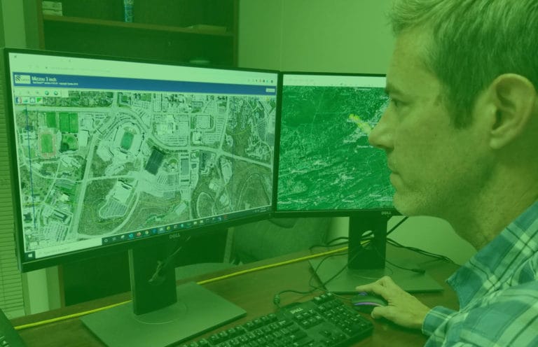
Flight Lines and Satellite
In these windows you can see densified flight lines, flown over urban areas with two different resolutions. The lines over urban areas also contain taller structures, and flight lines with greater sidelap are flown to reduce the effect of building lean.
The window at the right is a high-resolution satellite image over the area in the left window.